The challenge of open data

‘Oftentimes the barriers aren’t technical, they’re cultural – a tendency to horde information.’

‘How do people get information? Increasingly they go to the internet. Google and other browsers have conditioned people to go to Google. This is good and bad: the expectation has been built but the data is not always available (TERN, 2013).

Moreton Bay Seagrass Watch teamClick here to read more.

Access to others’ data is the way to answer the big questions.

‘Data exceeds the grasp of individuals.

Data is infrastructure. (TERN,  2013)

Click here to read more.

Moreton Bay Community Seagrass Watch makes it’s data freely available to anyone who wishes it.

Teasing out the small events that can cause big changes in an ecosystem

A new way of studying and visualizing Earth science data from a NASA and U.S. Geological Survey satellite program is resulting in, for the first time, the ability to tease out the small events that can cause big changes in an ecosystem.

Called LandTrendr, this computer program is able to find patterns previously buried within vast amounts of scientific data. Still in development, it’s already led to seeing for the first time in satellite imagery an obscured, slow-moving decline and recovery of trees in Pacific Northwest forests (Nasa, 2013)   Click here to read more.
satellite image (Nasa, 2013)

View Moreton Bay Seagrass Watch sites online

You can now view the Moreton Bay Community Seagrass Watch sites online. How? Simple, just click here to view the map.

You can view site and seagrass information at each site by clicking on the green flag relating to the site of interest.

At each site you will be able to view the seagrass data gathered in chart form.

To enlarge the chart on your screen just ‘right click‘ on the image and select ‘view image‘.

Map of Moreton Bay Seagrass Watch sites

Wynnum (WN3 & WN4) – big effort delivers good data since 2001

The Wynnum Moreton Bay Community Seagrass Watch teams have been active since 2001. Resulting in some great data and a history that spans over a decade. That’s an amazing amount of information and equally an amazing commitment.

These results are highlighted by the below charts. Click on them to enlarge.

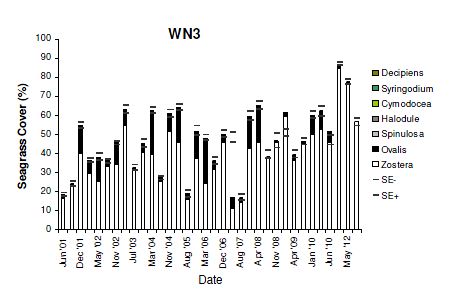
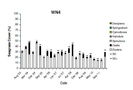
What these results confirm is that Eel grass, Zostera capricorni is the most common species of seagrass found in Moreton Bay and it certainly dominates the Western shores of Moreton Bay. While Dugong grass, Halophila ovalis is likewise common. This is a seagrass species preferred by dugongs. Interestingly while the larger herds of dugongs are certainly found on the Eastern sand banks of Moreton Bay, Wynnum and Ormiston on the Western side of Moreton Bay have their regular visitors. It was at Ormiston that a Moreton Bay Community Seagrass Watch team found abundant dugong feeding trails around the mouth of Hilliards Creek.

The results also show that despite the Western side of Moreton Bay suffering poor water clarity it can and often does support greater seagrass density.  Certainly there is a point when too much silt in the system kills off seagrass, such as Bramble Bay where over 1000 ha of seagrass was lost due to too much silt. The Wynnum foreshore however has a boundary with Waterloo Bay one of the healthiest embayments in Moreton Bay, regularly scoring B and better in the Healthy Waterways Report Card.

What WN3 and WN4 also help out with is developing a better understanding about the seasonal trends in seagrass biomass. Generally in summer seagrass growth is higher than in winter. WN3 & WN4 and other seagrass watch sites will be examined more closely over the next two years to help develop a better understanding of the trends in seagrass growth in Moreton Bay.  This knowledge goes a long way in helping us understand our impacts upon important and valuable coastal resources like seagrass. By monitoring seagrass and understanding its ecology better we can use it to guide us and alert us to adjust human activities so we can continue to enjoy the many free benefits seagrass delivers to us.
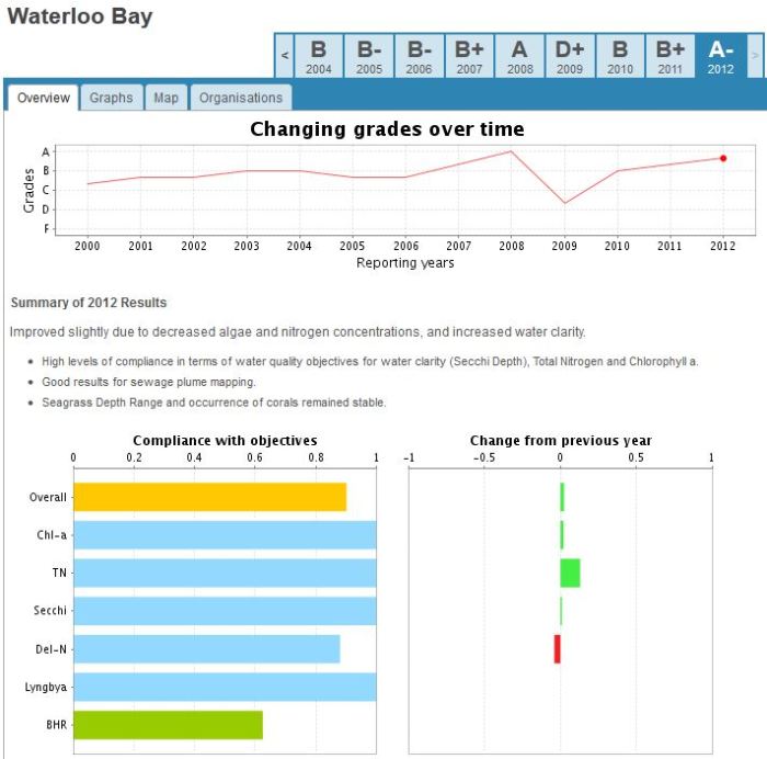
WN3 MBCSGW site

WN4 MBCSGW site

Waterloo Bay (Healthy Waterways)

Source: Healthy Waterwayshttp://www.health-e-waterways.org/reportcard/2012/bay-area/Waterloo%20Bay

A look at seagrass monitoring on Amity Banks (AB1) Moreton Bay

AB1 is located on Amity Banks in Moreton Bay.  See the below maps for details.
You can click on the maps (any image) to make them larger.

AB1 has been monitored by Deb, Frank and Megan, a team from Moreton Bay Community Seagrass Watch,  since 2005.  The result of their good work has allowed us to plot changes to seagrass density and types over that time. See the below chart. The most notable change seen on this chart is the sudden drop in seagrass biomass in April 2009. This records the damage caused by the 2009 stormy seas whipped up by cyclone Hamish. This is the storm where the Pacific Adventurer lost 31 containers over board just off Moreton Bay. Since then the data collected by the Moreton Bay Community Seagrass Watch team shows a slow but generally steady recovery at this site. However, the diversity of seagrass species has not yet returned to the same extent as seen prior to 2009.

Before 2009 AB1 supported many of the 7 species of seagrass that you would generally find in Moreton Bay.

Click on the below to see the before and after images of the 2009 storm damage comparison storm damage

Temperature is something the team also monitors at AB1 and a sample of the four (4) hourly monitoring data collected by our iButtons (electronic temperature monitors) is shown below.

With the April – March Seagrass Watch survey period fast approaching we and the AB1 team are keen to see the results of the recent 2013 floods. We will keep you posted on our findings.

AB1.a

AB1.b

ab1chart

Temp monitoring at AB1

Moreton Bay seagrass ok before 2013 floods but what about now?

Moreton Bay Community Seagrass Watch (MBCSGW) has been monitoring Moreton Bay seagrass meadows since 2001.

Given recent floods we are hoping to deploy as many MBCSGW teams as possible  during the 2013 March – April survey period. Understanding the status of our seagrass meadows after a major flood event goes a long way in helping us understand how we can better manage human activities so we can minimize our impacts upon valuable coastal resources such as seagrass.

seagrassavg

2013 March – April Moreton Bay Seagrass monitoring and Lyngbya

Lyngbya majuscula (Lyngbya) is a naturally occurring, thread-like, marine cyanobacterium.  It occurs naturally in Queensland coastal waters growing attached to seagrass, corals and other shallow substrates. On occasions it can grow rapidly to form an algal bloom. When the algae is in bloom proportions it often detaches from the substrate and floats in mats across the surface of the ocean where because it’s potentially toxic it can cause human health and odour problems.

Lyngbya can smother seagrass, coral and other benthic habitats. In significant bloom conditions, such as occurred in 2000 in Moreton Bay, blooms may be associated with reduced reproductive success in sea turtle species. This may be due to a food shortage impact because turtles avoid the seagrass covered in Lyngbya or due to the impact of Lyngbya toxins (EHP, 2012).

Lyngbya is is one of the variables that the Moreton Bay Community Seagrass Watch teams monitor as part of their regular 3 survey periods a year. The below chart plots Moreton Bay Community Seagrass Watch Lyngbya reports. Click here to learn more about Lyngbya. 

With the March – April survey fast approaching we are looking forward to Moreton Bay Community Seagrass Watch teams keeping an eye out for Lyngbya and reporting back its whereabouts.

lyngbya.chart